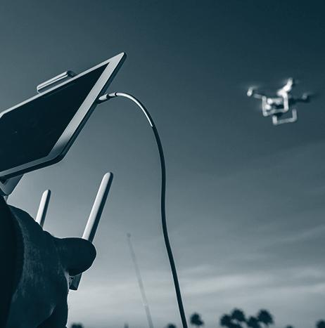
In an effort to improve safety in regards to shark attacks, UAS equipped with a shark detection system that is powered by artificial intelligence will be used to patrol some beaches in Australia starting in September.
After being provided a live-video feed via the battery-powered UAS, the UAS operator will use “shark-spotting software” to identify sharks in real time, with more accuracy than the human eye.
Studies have shown that when interpreting data from aerial images to detect shark activity, people have an accuracy rate between 20 and 30 percent.
According to Dr Nabin Sharma, a research associate at the University of Technology Sydney’s School of Software, that rate can be raised to 90 percent when using detection software.
Software
Software
Weekend Roundup
This Week in the Unmanned Systems and Robotics World
A startup company called May Mobility that is looking to offer its autonomous driving technology to companies with commercial fleets made its official debut on August 21 at Y Combinator’s demo day. May Mobility wants to focus on customers that have vehicle needs in areas where routes can be easily mapped and conditions are fairly predictable. This includes areas such as closed residential communities, business districts and campuses (school and corporate). (TechCrunch)

TuSimple to test driverless trucks in Tucson, Arizona after opening new office
TuSimple, which is a company based in China that is developing driverless commercial trucks, has opened an office in Tucson, Arizona, which will allow the company to test and demonstrate its vehicles in the city.
This will be TuSimple’s second office in the United States, as the company also has an office in San Diego.
“We believe that by leveraging the autonomous truck technology, we can help local economic growth by making Tucson the new nexus for [transportation logistics], and also sprout new job opportunities,” says TuSimple co-founder and Chief Technology Officer Xiaodi Hou, via Arizona Public Media.
U.S. Marine develops low-cost 3D-printed UAS
In 2015, the U.S. Marine Corps’ Next Generation Logistics innovation group, known as NexLog, was established to “advocate for the future of emerging technologies on the front lines and for equipping Marines with the ability to make solutions for their own environment.”
With this in mind, Rhet McNeal, a 26 year-old Corporal from Griffin, Georgia, developed a 3D-printed UAS nicknamed “Scout” that is a cheaper alternative to the hand-launched, fixed-wing RQ-11 Raven and RQ-12 Wasp III UAS that the Marines currently use.

Decorah Fire Department in Iowa uses UAS to find six people stranded along the Yellow River
In Eastern Iowa, the Allamakee County Sheriff's office enlisted the help of the Decorah Fire Department and its UAS to help locate six people who were stranded along the Yellow River near Effigy Mounds, after they got lost while tubing.
It took just 10 minutes for the UAS to locate the first three of the six stranded, after they were spotted using a heat seeking camera that was attached to the UAS.
Decorah Firefighter Zack Kerndt, who was at home when he got the call to put his UAS skills to work, says that a foot-search for the missing people would have been very difficult, which made the UAS that much more valuable.
Sharper Shape providing new UAS inspection service for electric utilities
A company that provides UAS-based inspections called Sharper Shape Inc. has announced that electric utilities can now utilize the company’s new automatic detail inspection (ADI) service.
The ADI service has completed field trials, and it is available as a “complete end-to-end inspection package.” Companies also have the option of using their own aircraft and personnel, and can use Sharper Shape’s ADI “Drone Software as A Service” to “maximize the efficiency of their in-house drone operations.”
3D Robotics’ Site Scan now includes ground control points
3D Robotics (3DR) has announced that ground control points (GCPs) are now available to be processed in its Site Scan UAS data platform for engineering and construction.
GCPs are “easily-identifiable markers on the ground of a jobsite that can be used to ‘georeference’ drone maps and models,” which makes it possible to not only increase the absolute accuracy of UAS data, but also creates superior deliverables such as orthomosaics, point clouds, and more.
“Ground control points are a game-changer for Site Scan,” says Chris Swigert of Liberty Excavators.
“Now, I can easily tag and process GCPs in the cloud, and deliver my clients more accurate drone maps and models than ever before.”

CompassDrone unveils CIRRUAS program for public safety uses
The Elbert County, Colorado, Sheriff’s Department will be one of the first departments in the country to participate in CompassDrone's Complete Incident Response Recovery Unmanned Aerial System (CIRRUAS) program, which is designed for public safety applications.
Based in Centennial, Colorado, CompassDrone, which provides UAS mapping consulting services, says that the CIRRUAS program is mainly designed for accident reconstruction and crime scene mapping, but it can also be used for search and rescue and reconnaissance operations as well.
India’s Flux Auto looking to create affordable self-driving technology for trucks
According to TechCrunch, a startup company in India called Flux Auto is looking to make autonomous driving technology “more widely available” for truck operators, especially those outside of the United States, by significantly lowering the cost of the technology.
Based in Bangalore, India, the 16-person startup would like to democratize autonomous systems, as it is working on technology that, when finished, could allow any kind of truck to be retrofitted with self-driving technology at a much lower price.