During AUSA 2017 in Washington, D.C., Roboteam, Inc., which provides tactical ground robotic systems and controllers for defense, law enforcement and public safety missions, unveiled its Transportable Interoperable Ground Robot (TIGR).
Described by Roboteam as the “most advanced, groundbreaking robotic platform ever made available to the modern warfighter,” the TIGR is a two-man carried UGV with a modular design. The modular design allows for add-ons, sensors and future technology integration.
Highly mobile and capable of operating in any terrain, the all-weather UGV is capable of a number of different functionalities that are unachievable for other mid-sized robotic platforms in the “theater of war,” according to Roboteam.
Technology
Technology
, photo courtesy of Business Wire.")
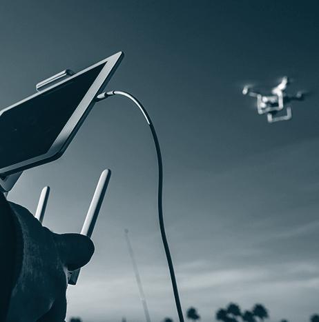
Washington State Patrol using UAS to fly over crash scenes
The Washington State Patrol (WSP) is crediting its UAS with helping to ease backups that are caused by crashes on the road.
Since the start of WSP’s pilot program back in July, UAS have been used to fly over 20 crash scenes.
According to Washington State Patrol Detective Eric Gunderson, one of the UAS named ‘Ice Man’ recently flew over a rollover crash that was blocking two lanes of traffic on Interstate-5 in Tacoma, Washington.
Gunderson says that using the UAS, he was able to capture more than 200 digital photos, which allowed him to document the scene in just over 20 minutes. It would have taken three to four hours to document the scene without the UAS, according to Gunderson.

Weekend Roundup
This Week in the Unmanned Systems and Robotics World
On the same day as World Animal Day, Oct. 4, Intel announced that it successfully used its artificial intelligence (AI) and UAS technologies for two wildlife research expeditions; one which focused on polar bear exploration, and the other on whale exploration. The expeditions were conducted through two separate collaborations with a wildlife photographer and conservationist, and also with Parley for the Oceans, which addresses major threats towards the world’s oceans. (Intel)

Insitu and Esri collaborate to test UAS for fighting wildfires
Insitu, along with Esri, which is a company that builds mapping and spatial analytics software, has successfully completed test flights using state-of-the-art software to support the firefighting efforts of firefighters and first responders.
The flights, which were held at the Warm Springs, Oregon FAA UAS Test Range, were aimed at helping firefighters suppress the Eagle Creek fire in Oregon, using Insitu’s INEXA Solutions professional aerial remote sensing teams, and the company's ScanEagle UAS.
Israel Aerospace Industries demonstrates capabilities of its unmanned and autonomous systems
Unmanned systems from Israel Aerospace Industries (IAI) have successfully completed a “proof of concept” to high officials of the defense industry and the Israel Defense Forces (IDF).
The Air Hopper unmanned helicopter, which was recently developed by IAI and is mainly used for providing “fast logistic supplies to sites where ground access is difficult or dangerous,” took part in a two-scenario demonstration.
One scenario simulated carrying a soldier that was seriously injured to an extraction point for “life-saving treatment, airborne monitoring of vital signs and real-time dispatch to the ground.”
The second scenario simulated “carrying logistic supplies to an isolated force at the front line” which wouldn't be accessible without putting more troops at risk.

Revolution Aviation and Ultimate Drone Productions to offer UAS cinematography services
Flight school Revolution Aviation has partnered with aerial photography company Ultimate Drone Productions to begin offering cinematography services via UAS.
Through this partnership, Newport Beach, California-based Revolution Aviation—primarily known as its U.S.-registered trademark EatSleepFly—and Ultimate Drone Productions will provide a “full service photo and video cinematography production services.”
According to a press release published by Vertical Magazine, the demand for aerial imagery in Southern California is out-pacing supply, as there are just approximately 20,000 registered commercial UAS services in all 50 states.
First part of 50-mile UTM corridor in New York launches
The first part of the 50-mile Unmanned Traffic Management Corridor in New York has launched.
The corridor now consists of a five-mile circle around Griffiss International Airport. That part of the corridor is equipped with special sensors and radars that can detect small UAS flying at very low altitudes, which is a feature that is not included in traditional radars around airports.
Using $30 million in state funding, the corridor will be expanded next year into a “50-mile-long air space” stretching from Rome to Syracuse, according to Northeast UAS Airspace Integration Research Alliance (NUAIR) President and CEO Larry Brinker.
Hydroid teams with industry partners to demonstrate latest UUV capabilities during ANTX 2017
In August, during an advanced naval technology exercise known as ANTX in Newport, Rhode Island, Hydroid, Inc., L3 Aerospace Systems, Sparton Corporation and AeroVironment, Inc. collaborated to demonstrate the latest UUV capabilities of the Hydroid REMUS 600 UUV through a threat mission scenario conducted in the water.
The UUV was equipped with L3’s Rio Nino signals intelligence (SIGINT) collection payload, as well as a Sparton Hammerhead canister that contained an AeroVironment Blackwing UAV, which was launched during the exercise.

Weekend Roundup
This Week in the Unmanned Systems and Robotics World
During the 2nd Quarter of 2017, SeekOps Incorporated used “proprietary miniature gas sensors” on advanced UAS platforms to detect the primary component of natural gas, methane. Compared to current leak detection operations which are conducted by vehicles or on foot using large instrumentation, the UAS deployment provides increased efficiency. SeekOps used UAS by an industrial-grade UAS platform manufacturer called Straight Up Imaging. (SeekOps)
Virginia Governor Terry McAuliffe operates unmanned systems in three domains
During a technology demonstration at the Mid-Atlantic Regional Unmanned Aircraft Systems (MARUAS) Airfield at NASA’s Wallops Flight Facility in coastal Virginia, Virginia Governor Terry McAuliffe operated unmanned systems in three domains—air, land, and sea.
The demonstration showcased how unmanned systems are being used by scientists to study the effects of major storms and sea-level rise on barrier-island dynamics, in an effort to form policies for coastal resilience.